Weather Alert in New York
Air Quality Alert issued June 7 at 4:08PM EDT by NWS Albany NY
AREAS AFFECTED: Northern Herkimer; Hamilton; Southern Herkimer; Northern Warren
DESCRIPTION: The New York State Department of Environmental Conservation at Albany has issued a Air Quality Health Advisory for Fine Particulates.. until midnight EDT tonight. Air quality levels in outdoor air are predicted to be greater than an air quality index value of 100 for Fine Particulates. The air quality index...or AQI...was created as an easy way to correlate levels of different pollutants to one scale. The higher the AQI value, the greater the health concern. When pollution levels are elevated...the New York State Department of Health recommends that individuals consider limiting strenuous outdoor physical activity to reduce the risk of adverse health effects. People who may be especially sensitive to the effects of elevated levels of pollutants include the very young and those with pre existing respiratory problems such as asthma or heart disease. Those with symptoms should consider consulting their personal physician. For additional information, please visit the New York State Department of Environmental Conservation website at, https://on.ny.gov/nyaqi, or call the Air Quality Hotline at 800-535- 1345.
INSTRUCTION: N/A
Want more detail? Get the Complete 7 Day and Night Detailed Forecast!
Current U.S. National Radar--Current
The Current National Weather Radar is shown below with a UTC Time (subtract 5 hours from UTC to get Eastern Time).

National Weather Forecast--Current
The Current National Weather Forecast and National Weather Map are shown below.

National Weather Forecast for Tomorrow
Tomorrow National Weather Forecast and Tomorrow National Weather Map are show below.

North America Water Vapor (Moisture)
This map shows recent moisture content over North America. Bright and colored areas show high moisture (ie, clouds); brown indicates very little moisture present; black indicates no moisture.

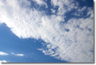
Weather Topic: What are Stratus Clouds?
Home - Education - Cloud Types - Stratus Clouds
 Next Topic: Wall Clouds
Stratus clouds are similar to altostratus clouds, but form at a
lower altitude and are identified by their fog-like appearance, lacking the
distinguishing features of most clouds.
Stratus clouds are wider than most clouds, and their base has a smooth, uniform
look which is lighter in color than a nimbostratus cloud.
The presence of a stratus cloud indicates the possibility of minor precipitation,
such as drizzle, but heavier precipitation does not typically arrive in the form
of a stratus cloud.
Next Topic: Wall Clouds
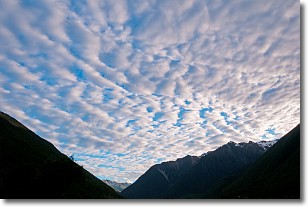
Weather Topic: What are Altocumulus Clouds?
Home - Education - Cloud Types - Altocumulus Clouds
 Next Topic: Altostratus Clouds
Similar to cirrocumulus clouds, altocumulus clouds are
characterized by cloud patches. They are distinguished by larger cloudlets
than cirrocumulus clouds but are still smaller than stratocumulus clouds.
Altocumulus clouds most commonly form in middle altitudes (between 2 and 5 km)
and may resemble, at times, the shape of a flying saucer.
These uncommon formations, called altocumulus lenticularis, are created by uplift
in the atmosphere and are most often seen in close proximity to mountains.
Next Topic: Altostratus Clouds
Current conditions powered by WeatherAPI.com


