Weather Alert in Minnesota
Dense Fog Advisory issued September 11 at 3:37AM CDT until September 11 at 11:00AM CDT by NWS Duluth MN
AREAS AFFECTED: Koochiching; North St. Louis; Northern Cook/Northern Lake; North Itasca; Central St. Louis; Southern Lake/North Shore; Southern Cook/North Shore; North Cass; South Itasca; South Cass; Crow Wing; Northern Aitkin; South Aitkin; Carlton/South St. Louis; Pine; Douglas; Bayfield; Ashland; Iron; Burnett; Washburn; Sawyer; Price
DESCRIPTION: * WHAT...Visibility one quarter mile or less in dense fog. * WHERE...In Minnesota, Crow Wing, Aitkin, Pine, Koochiching, Cass, Itasca, Carlton, St. Louis, Cook and Lake Counties. In Wisconsin, Price, Ashland, Bayfield, Burnett, Douglas, Iron, Sawyer, and Washburn Counties. This includes the Tribal Lands of the northwestern area of the Lac du Flambeau Band, the Grand Portage Reservation, the Bad River Reservation, the Lac Courte Oreilles Reservation, the Fond du Lac Band, the St. Croix Band in Burnett County, the Red Cliff Band, the Mille Lacs Band, East Lake, Hinckley, Lena Lake and, Big Sandy Lake areas and the Bois Forte Band, Lake Vermilion, Deer Creek and, Nett Lake areas. Other locations including Voyageurs National Park, Madeline Island and the Apostle Islands National Lakeshore. The entire Boundary Waters is also included. * WHEN...Until 11 AM CDT this morning. * IMPACTS...Low visibility could make driving conditions hazardous.
INSTRUCTION: If driving, slow down, use your low-beam headlights and fog lights, and leave plenty of distance ahead of you.
Want more detail? Get the Complete 7 Day and Night Detailed Forecast!
Current U.S. National Radar--Current
The Current National Weather Radar is shown below with a UTC Time (subtract 5 hours from UTC to get Eastern Time).

National Weather Forecast--Current
The Current National Weather Forecast and National Weather Map are shown below.

National Weather Forecast for Tomorrow
Tomorrow National Weather Forecast and Tomorrow National Weather Map are show below.

North America Water Vapor (Moisture)
This map shows recent moisture content over North America. Bright and colored areas show high moisture (ie, clouds); brown indicates very little moisture present; black indicates no moisture.

Weather Topic: What are Altostratus Clouds?
Home - Education - Cloud Types - Altostratus Clouds
 Next Topic: Cirrocumulus Clouds
Altostratus clouds form at mid to high-level altitudes
(between 2 and 7 km) and are created by a warm, stable air mass which causes
water vapor
to condense as it rise through the atmosphere. Usually altostratus clouds are
featureless sheets characterized by a uniform color.
In some cases, wind punching through the cloud formation may give it a waved
appearance, called altostratus undulatus. Altostratus clouds
are commonly seen with other cloud formations accompanying them.
Next Topic: Cirrocumulus Clouds
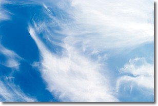
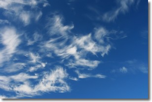
Weather Topic: What are Cirrostratus Clouds?
Home - Education - Cloud Types - Cirrostratus Clouds
 Next Topic: Cirrus Clouds
Cirrostratus clouds are high, thin clouds that form above
20,000 feet and are made mostly of ice crystals. They sometimes look like giant
feathers, horse tails, or curls of hair in the sky.
These clouds are pushed by the jet stream and can move at high speeds reaching
100 mph.
What do they indicate?
They indicate that a precipitation is likely within 24 hours.
Next Topic: Cirrus Clouds
Current conditions powered by WeatherAPI.com


