Weather Alert in Montana
Special Weather Statement issued September 11 at 10:48AM MDT by NWS Billings MT
AREAS AFFECTED: Northern Stillwater; Northern Big Horn; Southern Big Horn; Northern Carbon; Pryor/Northern Bighorn Mountains; Southwestern Yellowstone
DESCRIPTION: At 1048 AM MDT, Doppler radar was tracking a line of strong thunderstorms extending from 14 miles northeast of Columbus to 31 miles southeast of Billings, moving northeast at 25 mph. HAZARD...Wind gusts of 40 to 50 mph and brief heavy rainfall. SOURCE...Radar indicated. IMPACT...Gusty winds could knock down tree limbs and blow around unsecured objects. Locations impacted include... Billings, Laurel, Billings West End, Billings Heights, Lockwood, Shepherd, Huntley, Pryor, Broadview, Acton, Silesia, Comanche, Park City, Molt and Crow Indian Reservation.
INSTRUCTION: Monitor the weather situation closely and be alert for threatening weather conditions.
Want more detail? Get the Complete 7 Day and Night Detailed Forecast!
Current U.S. National Radar--Current
The Current National Weather Radar is shown below with a UTC Time (subtract 5 hours from UTC to get Eastern Time).

National Weather Forecast--Current
The Current National Weather Forecast and National Weather Map are shown below.

National Weather Forecast for Tomorrow
Tomorrow National Weather Forecast and Tomorrow National Weather Map are show below.

North America Water Vapor (Moisture)
This map shows recent moisture content over North America. Bright and colored areas show high moisture (ie, clouds); brown indicates very little moisture present; black indicates no moisture.

Weather Topic: What are Cirrus Clouds?
Home - Education - Cloud Types - Cirrus Clouds
 Next Topic: Condensation
Cirrus clouds are high-level clouds that occur above 20,000 feet
and are composed mainly of ice crystals.
They are thin and wispy in appearance.
What do they indicate?
They are often the first sign of an approaching storm.
Next Topic: Condensation
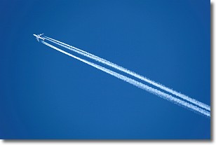
Weather Topic: What are Contrails?
Home - Education - Cloud Types - Contrails
 Next Topic: Cumulonimbus Clouds
A contrail is an artificial cloud, created by the passing of an
aircraft.
Contrails form because water vapor in the exhaust of aircraft engines is suspended
in the air under certain temperatures and humidity conditions. These contrails
are called exhaust contrails.
Another type of contrail can form due to a temporary reduction in air pressure
moving over the plane's surface, causing condensation.
These are called aerodynamic contrails.
When you can see your breath on a cold day, it is also because of condensation.
The reason contrails last longer than the condensation from your breath is
because the water in contrails freezes into ice particles.
Next Topic: Cumulonimbus Clouds
Current conditions powered by WeatherAPI.com


