Weather Alert in Minnesota
Air Quality Alert issued June 7 at 5:38PM CDT by NWS Twin Cities/Chanhassen MN
AREAS AFFECTED: Douglas; Todd; Morrison; Mille Lacs; Kanabec; Stevens; Pope; Stearns; Benton; Sherburne; Isanti; Chisago; Lac Qui Parle; Swift; Chippewa; Kandiyohi; Meeker; Wright; Hennepin; Anoka; Ramsey; Washington; Yellow Medicine; Renville; McLeod; Sibley; Carver; Scott; Dakota; Redwood; Brown; Nicollet; Le Sueur; Rice; Goodhue; Watonwan; Blue Earth; Waseca; Steele; Martin; Faribault; Freeborn
DESCRIPTION: * WHAT...The Minnesota Pollution Control Agency has issued an Air Quality Alert for fine particles pollution. The Air Quality Index (AQI) is expected to reach the Orange or Unhealthy for Sensitive Groups category. * WHERE...All of Minnesota. * WHEN...From 11 PM CDT Friday evening to 11 PM CDT Sunday evening. * IMPACTS...Sensitive groups, such as people with lung disease (including asthma), heart disease, and children and older adults, may experience health effects. * ADDITIONAL DETAILS...Heavy surface Canadian wildfire smoke will follow a cold front into and across Minnesota from west to east from late Saturday night into Sunday morning and afternoon, and then clear out from west to east across the state from Sunday afternoon through Sunday evening. Some areas may only see a few hours of alert-level smoke concentrations due to the relatively fast movement of the north-south band of smoke. The air quality alert may need to be extended into Monday if an additional batch of heavy smoke materializes from Manitoba and Saskatchewan wildfires and then is transported into and across Minnesota from north to south, but confidence for this outcome is currently low to medium.
INSTRUCTION: Sensitive groups, such as people with lung disease (including asthma), heart disease, and children and older adults, should limit prolonged or heavy exertion. Reduce or eliminate activities that contribute to air pollution, such as outdoor burning, and use of residential wood burning devices. Reduce vehicle trips and vehicle idling as much as possible. Keep windows closed overnight to prevent smoke from getting indoors.
Want more detail? Get the Complete 7 Day and Night Detailed Forecast!
Current U.S. National Radar--Current
The Current National Weather Radar is shown below with a UTC Time (subtract 5 hours from UTC to get Eastern Time).

National Weather Forecast--Current
The Current National Weather Forecast and National Weather Map are shown below.

National Weather Forecast for Tomorrow
Tomorrow National Weather Forecast and Tomorrow National Weather Map are show below.

North America Water Vapor (Moisture)
This map shows recent moisture content over North America. Bright and colored areas show high moisture (ie, clouds); brown indicates very little moisture present; black indicates no moisture.

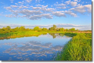
Weather Topic: What are Stratocumulus Clouds?
Home - Education - Cloud Types - Stratocumulus Clouds
 Next Topic: Stratus Clouds
Stratocumulus clouds are similar to altocumulus clouds in their
fluffy appearance, but have a slightly darker shade due to their additional mass.
A good way to distinguish the two cloud types is to hold your hand out and measure
the size of an individual cloud; if it is the size of your thumb it is generally
an altocumulus cloud, if it is the size of your hand it is generally a
stratocumulus cloud.
It is uncommon for stratocumulus clouds to produce precipitation, but if they do
it is usually a light rain or snow.
Next Topic: Stratus Clouds
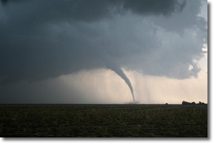
Weather Topic: What are Wall Clouds?
Home - Education - Cloud Types - Wall Clouds
 Next Topic: Altocumulus Clouds
A wall cloud forms underneath the base of a cumulonimbus cloud,
and can be a hotbed for deadly tornadoes.
Wall clouds are formed by air flowing into the cumulonimbus clouds, which can
result in the wall cloud descending from the base of the cumulonimbus cloud, or
rising fractus clouds which join to the base of the storm cloud as the wall cloud
takes shape.
Wall clouds can be very large, and in the Northern Hemisphere they generally
form at the southern edge of cumulonimbus clouds.
Next Topic: Altocumulus Clouds
Current conditions powered by WeatherAPI.com


