Weather Alert in Texas
Flood Warning issued July 4 at 5:23AM CDT until July 5 at 4:05AM CDT by NWS Austin/San Antonio TX
AREAS AFFECTED: Kendall, TX
DESCRIPTION: ...The National Weather Service in Austin/San Antonio TX has issued a Flood Warning for the following rivers in Texas... Guadalupe River At Comfort affecting Kendall County. * WHAT...Moderate flooding is forecast. * WHERE...Guadalupe River at Comfort. * WHEN...From this morning to late tonight. * IMPACTS...At 26.0 feet, Moderate flooding in the Guadalupe River backs up Cypress Creek in the west edge of Comfort and additional heavy runoff down Cypress Creek floods the lowest homes. Low roads, bridges, and crossings over the Guadalupe River are very dangerous. * ADDITIONAL DETAILS... - At 4:45 AM CDT Friday the stage was 3.1 feet. - Bankfull stage is 10.0 feet. - Forecast...The river will rise above flood stage late this morning to 26.4 feet this afternoon. It will then fall below flood stage late this afternoon to 8.2 feet just after midnight tonight. It will rise to 8.8 feet just after midnight tonight. It will then fall again and remain below flood stage. - Flood stage is 21.0 feet. - Flood History...This crest compares to a previous crest of 26.7 feet on 05/24/2015. - http://www.weather.gov/safety/flood
INSTRUCTION: Turn around, don't drown when encountering flooded roads. Most flood deaths occur in vehicles. Be especially cautious at night when it is harder to recognize the dangers of flooding. To escape rising water, take the shortest path to higher ground. Additional information is available at www.weather.gov. The next statement will be issued this evening by 1130 PM CDT.
Want more detail? Get the Complete 7 Day and Night Detailed Forecast!
Current U.S. National Radar--Current
The Current National Weather Radar is shown below with a UTC Time (subtract 5 hours from UTC to get Eastern Time).

National Weather Forecast--Current
The Current National Weather Forecast and National Weather Map are shown below.

National Weather Forecast for Tomorrow
Tomorrow National Weather Forecast and Tomorrow National Weather Map are show below.

North America Water Vapor (Moisture)
This map shows recent moisture content over North America. Bright and colored areas show high moisture (ie, clouds); brown indicates very little moisture present; black indicates no moisture.

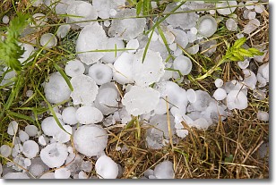
Weather Topic: What is Hail?
Home - Education - Precipitation - Hail
 Next Topic: Hole Punch Clouds
Hail is a form of precipitation which is recognized by large solid balls or
clumps of ice. Hail is created by thunderstorm clouds with strong updrafts of wind.
As the hailstones remain in the updraft, ice is deposited onto them until their
weight becomes heavy enough for them to fall to the earth's surface.
Hail storms can cause significant damage to crops, aircrafts, and man-made structures,
despite the fact that the duration is usually less than ten minutes.
Next Topic: Hole Punch Clouds
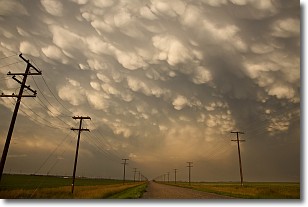
Weather Topic: What are Mammatus Clouds?
Home - Education - Cloud Types - Mammatus Clouds
 Next Topic: Nimbostratus Clouds
A mammatus cloud is a cloud with a unique feature which resembles
a web of pouches hanging along the base of the cloud.
In the United States, mammatus clouds tend to form in the warmer months, commonly
in the Midwest and eastern regions.
While they usually form at the bottom of a cumulonimbis cloud, they can also form
under altostratus, altocumulus, stratocumulus, and cirrus clouds. Mammatus clouds
warn that severe weather is close.
Next Topic: Nimbostratus Clouds
Current conditions powered by WeatherAPI.com


