Weather Alert in California
Beach Hazards Statement issued September 11 at 8:18PM PDT until September 12 at 8:00AM PDT by NWS Eureka CA
AREAS AFFECTED: Coastal Del Norte; Northern Humboldt Coast; Southwestern Humboldt
DESCRIPTION: * WHAT...Increased threat of sneaker waves expected. * WHERE...Coastal Del Norte, Northern Humboldt Coast and Southwestern Humboldt Counties. * WHEN...Until 8 AM PDT Friday. . * IMPACTS...Large, unexpected waves can sweep across the beach without warning, sweeping people into the sea from rocks, jetties, and beaches. These sneaker waves can also move large objects such as logs, crushing anyone caught underneath.
INSTRUCTION: Don't be fooled by an ocean that looks calm. There can be 30 minutes of small waves before a sneaker wave strikes. Avoid rocks and jetties. Avoid steep beaches. Stay much farther back from the water and never turn your back on the ocean.
Want more detail? Get the Complete 7 Day and Night Detailed Forecast!
Current U.S. National Radar--Current
The Current National Weather Radar is shown below with a UTC Time (subtract 5 hours from UTC to get Eastern Time).

National Weather Forecast--Current
The Current National Weather Forecast and National Weather Map are shown below.

National Weather Forecast for Tomorrow
Tomorrow National Weather Forecast and Tomorrow National Weather Map are show below.

North America Water Vapor (Moisture)
This map shows recent moisture content over North America. Bright and colored areas show high moisture (ie, clouds); brown indicates very little moisture present; black indicates no moisture.

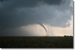
Weather Topic: What are Wall Clouds?
Home - Education - Cloud Types - Wall Clouds
 Next Topic: Altocumulus Clouds
A wall cloud forms underneath the base of a cumulonimbus cloud,
and can be a hotbed for deadly tornadoes.
Wall clouds are formed by air flowing into the cumulonimbus clouds, which can
result in the wall cloud descending from the base of the cumulonimbus cloud, or
rising fractus clouds which join to the base of the storm cloud as the wall cloud
takes shape.
Wall clouds can be very large, and in the Northern Hemisphere they generally
form at the southern edge of cumulonimbus clouds.
Next Topic: Altocumulus Clouds
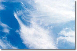
Weather Topic: What are Altostratus Clouds?
Home - Education - Cloud Types - Altostratus Clouds
 Next Topic: Cirrocumulus Clouds
Altostratus clouds form at mid to high-level altitudes
(between 2 and 7 km) and are created by a warm, stable air mass which causes
water vapor
to condense as it rise through the atmosphere. Usually altostratus clouds are
featureless sheets characterized by a uniform color.
In some cases, wind punching through the cloud formation may give it a waved
appearance, called altostratus undulatus. Altostratus clouds
are commonly seen with other cloud formations accompanying them.
Next Topic: Cirrocumulus Clouds
Current conditions powered by WeatherAPI.com


