Weather Alert in Alaska
Special Weather Statement issued September 10 at 2:56PM AKDT by NWS Fairbanks AK
AREAS AFFECTED: Northwest Arctic Coast; Northern Arctic Coast; Central Beaufort Sea Coast; Eastern Beaufort Sea Coast; Western Arctic Plains; Howard Pass and the Delong Mountains; Central Arctic Plains; Central Brooks Range; Romanzof Mountains
DESCRIPTION: Accumulating wet snow continues through tonight into Thursday, before tapering off Thursday night into Friday morning. Several inches of wet snow and gusty northeasterly winds are expected across much of the North Slope. Accumulations up to 4 inches expected for most of the Arctic Plains and along the Western Arctic Coast, with lesser amounts expected along the Eastern Arctic coast where on- shore winds are expected to keep temperatures slightly warmer resulting in more of a rain/snow mix. The heaviest amounts occur in the Brooks Range, including Atigun and Anaktuvuk Pass, where totals will be around 4 to 8 inches. Drier conditions expected this weekend into next week. Hunters, recreators, and travelers are encouraged to prepare for wintry conditions through Friday morning and to monitor the latest forecast for updates.
INSTRUCTION: N/A
Want more detail? Get the Complete 7 Day and Night Detailed Forecast!
Current U.S. National Radar--Current
The Current National Weather Radar is shown below with a UTC Time (subtract 5 hours from UTC to get Eastern Time).

National Weather Forecast--Current
The Current National Weather Forecast and National Weather Map are shown below.

National Weather Forecast for Tomorrow
Tomorrow National Weather Forecast and Tomorrow National Weather Map are show below.

North America Water Vapor (Moisture)
This map shows recent moisture content over North America. Bright and colored areas show high moisture (ie, clouds); brown indicates very little moisture present; black indicates no moisture.

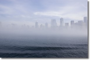
Weather Topic: What is Fog?
Home - Education - Cloud Types - Fog
 Next Topic: Fractus Clouds
Fog is technically a type of stratus cloud, which lies along the
ground and obscures visibility.
It is usually created when humidity in the air condenses into tiny water droplets.
Because of this, some places are more prone to foggy weather, such as regions
close to a body of water.
Fog is similar to mist; both are the appearance of water droplets suspended in
the air, but fog is the term applied to the condition when visibility is less than 1 km.
Next Topic: Fractus Clouds
Weather Topic: What is Freezing Rain?
Home - Education - Precipitation - Freezing Rain
 Next Topic: Graupel
Freezing rain is a condition where precipitation which has fallen in the form of
water droplets reaches temperatures which are below freezing and freezes upon
coming into contact
with surface objects. The result of this precipitation is a glaze of ice which
can be damaging to plants and man-made structures. A severe onset of freezing
rain which results in a very thick glaze of ice is known as an ice storm.
Next Topic: Graupel
Current conditions powered by WeatherAPI.com


