Weather Alerts for Florida
1. Flood Advisory for: Palm Beach, FL
2. Flood Advisory for: Palm Beach, FL
3. Flood Watch for: Coastal Indian River; Coastal St. Lucie; Coastal Martin; Inland Indian River; Inland St. Lucie; Inland Martin
4. Flood Watch for: Inland Volusia; Coastal Volusia; Inland Northern Brevard; Mainland Northern Brevard; Northern Brevard Barrier Islands; Inland Southern Brevard; Mainland Southern Brevard; Southern Brevard Barrier Islands
5. Flood Watch for: Metro Palm Beach County; Metro Broward County; Metropolitan Miami Dade; Coastal Palm Beach County; Coastal Broward County; Coastal Miami Dade County
6. High Surf Advisory for: Coastal Indian River; Mainland Southern Brevard; Southern Brevard Barrier Islands
7. High Surf Advisory for: Coastal Nassau; Coastal Duval; Coastal Flagler; Northeast Coastal St. Johns; Southeast Coastal St. Johns; Coastal Glynn; Coastal Camden
8. High Surf Advisory for: Coastal St. Lucie; Coastal Martin
9. High Surf Advisory for: Coastal Volusia
10. High Surf Advisory for: Mainland Northern Brevard; Northern Brevard Barrier Islands
11. Red Flag Warning for: Central Walton; Holmes; Washington; Jackson; Inland Bay; Calhoun; Inland Gulf; Gadsden; Leon; Coastal Bay; Northern Liberty; Southern Liberty; Dougherty; Worth; Turner; Tift; Ben Hill; Irwin; Miller; Baker; Mitchell; Colquitt; Cook; Berrien; Seminole; Decatur; Grady; Thomas; Brooks
12. Red Flag Warning for: South Walton
13. Rip Current Statement for: Coastal Franklin
14. Rip Current Statement for: Coastal Indian River; Mainland Southern Brevard; Southern Brevard Barrier Islands
15. Rip Current Statement for: Coastal Nassau; Coastal Duval; Coastal Flagler; Northeast Coastal St. Johns; Southeast Coastal St. Johns; Coastal Glynn; Coastal Camden
16. Rip Current Statement for: Coastal Palm Beach County; Coastal Broward County; Coastal Miami Dade County
17. Rip Current Statement for: Coastal St. Lucie; Coastal Martin
18. Rip Current Statement for: Coastal Volusia
19. Rip Current Statement for: Mainland Northern Brevard; Northern Brevard Barrier Islands
20. Wind Advisory for: Coastal Indian River; Coastal St. Lucie; Inland Indian River; Inland St. Lucie
21. Wind Advisory for: Coastal Martin; Inland Martin
22. Wind Advisory for: Coastal Nassau; Coastal Duval; Coastal Flagler; Northeast Coastal St. Johns; Southeast Coastal St. Johns
23. Wind Advisory for: Inland Flagler; Eastern Clay; Eastern Putnam; South Central Duval; Northern Inland St. Johns; Southern Inland St. Johns; Western St. Johns
24. Wind Advisory for: Inland Northern Brevard; Mainland Northern Brevard; Northern Brevard Barrier Islands; Inland Southern Brevard; Mainland Southern Brevard; Southern Brevard Barrier Islands
25. Wind Advisory for: Inland Volusia; Coastal Volusia
26. Wind Advisory for: Northern Lake County; Orange; Seminole; Osceola; Southern Lake County
27. Wind Advisory for: Okeechobee
Want more detail? Get the Complete 7 Day and Night Detailed Forecast!
Current U.S. National Radar--Current
The Current National Weather Radar is shown below with a UTC Time (subtract 5 hours from UTC to get Eastern Time).

National Weather Forecast--Current
The Current National Weather Forecast and National Weather Map are shown below.

National Weather Forecast for Tomorrow
Tomorrow National Weather Forecast and Tomorrow National Weather Map are show below.

North America Water Vapor (Moisture)
This map shows recent moisture content over North America. Bright and colored areas show high moisture (ie, clouds); brown indicates very little moisture present; black indicates no moisture.

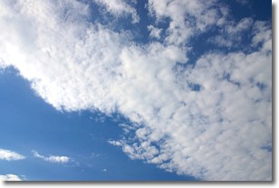
Weather Topic: What are Altocumulus Clouds?
Home - Education - Cloud Types - Altocumulus Clouds
 Next Topic: Altostratus Clouds
Similar to cirrocumulus clouds, altocumulus clouds are
characterized by cloud patches. They are distinguished by larger cloudlets
than cirrocumulus clouds but are still smaller than stratocumulus clouds.
Altocumulus clouds most commonly form in middle altitudes (between 2 and 5 km)
and may resemble, at times, the shape of a flying saucer.
These uncommon formations, called altocumulus lenticularis, are created by uplift
in the atmosphere and are most often seen in close proximity to mountains.
Next Topic: Altostratus Clouds
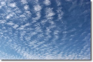
Weather Topic: What are Cirrocumulus Clouds?
Home - Education - Cloud Types - Cirrocumulus Clouds
 Next Topic: Cirrostratus Clouds
Cirrocumulus clouds form at high altitudes (usually around 5 km)
and have distinguishing characteristics displayed in a fine layer of
small cloud patches. These small cloud patches are sometimes referred to as
"cloudlets" in relation to the whole cloud formation.
Cirrocumulus clouds are formed from ice crystals and water droplets. Often, the
water droplets in the cloud freeze into ice crystals and the cloud becomes a
cirrostratus cloud. Because of this common occurrence, cirrocumulus cloud
formations generally pass rapidly.
Next Topic: Cirrostratus Clouds
Current conditions powered by WeatherAPI.com


