Weather Alerts for New Mexico
1. Freeze Warning for: Central Highlands; Far Northeast Highlands; Northeast Highlands
2. Freeze Warning for: Eastern San Miguel County
3. Freeze Warning for: Harding County
4. Freeze Warning for: Middle Rio Grande Valley/Albuquerque Metro Area; San Agustin Plains and Adjacent Lowlands
5. Freeze Warning for: Northwest Plateau; Espanola Valley; Santa Fe Metro Area; Estancia Valley; South Central Highlands; Guadalupe County
6. Freeze Warning for: Union County; Quay County
7. High Wind Warning for: Guadalupe Mountains of Eddy County; Guadalupe Mountains Above 7000 Feet
8. Red Flag Warning for: Northeast Plains; Northeast Highlands; Sandia and Manzano Mountains; Central Highlands; East Central Plains
9. Red Flag Warning for: Sacramento Foothills and Guadalupe Mountains; Chaves County Plains; Eddy Plains; Lea; Gaines; Dawson; Andrews; Guadalupe Mountains Above 7000 Feet; Guadalupe and Delaware Mountains; Eastern Culberson County
10. Red Flag Warning for: Southwest Mountains; Southwest Deserts and Lowlands; South Central Lowlands And Southern Rio Grande Valley; Capitan And Sacramento Mountains
11. Wind Advisory for: Central Highlands; Far Northeast Highlands; Northeast Highlands
12. Wind Advisory for: Curry County
13. Wind Advisory for: Eastern San Miguel County
14. Wind Advisory for: Harding County
15. Wind Advisory for: Northern Sangre de Cristo Mountains; Southern Sangre de Cristo Mountains; East Slopes Sangre de Cristo Mountains; South Central Mountains; Southwest Chaves County
16. Wind Advisory for: Union County; Quay County
Want more detail? Get the Complete 7 Day and Night Detailed Forecast!
Current U.S. National Radar--Current
The Current National Weather Radar is shown below with a UTC Time (subtract 5 hours from UTC to get Eastern Time).

National Weather Forecast--Current
The Current National Weather Forecast and National Weather Map are shown below.

National Weather Forecast for Tomorrow
Tomorrow National Weather Forecast and Tomorrow National Weather Map are show below.

North America Water Vapor (Moisture)
This map shows recent moisture content over North America. Bright and colored areas show high moisture (ie, clouds); brown indicates very little moisture present; black indicates no moisture.

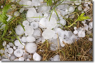
Weather Topic: What is Hail?
Home - Education - Precipitation - Hail
 Next Topic: Hole Punch Clouds
Hail is a form of precipitation which is recognized by large solid balls or
clumps of ice. Hail is created by thunderstorm clouds with strong updrafts of wind.
As the hailstones remain in the updraft, ice is deposited onto them until their
weight becomes heavy enough for them to fall to the earth's surface.
Hail storms can cause significant damage to crops, aircrafts, and man-made structures,
despite the fact that the duration is usually less than ten minutes.
Next Topic: Hole Punch Clouds
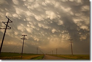
Weather Topic: What are Mammatus Clouds?
Home - Education - Cloud Types - Mammatus Clouds
 Next Topic: Nimbostratus Clouds
A mammatus cloud is a cloud with a unique feature which resembles
a web of pouches hanging along the base of the cloud.
In the United States, mammatus clouds tend to form in the warmer months, commonly
in the Midwest and eastern regions.
While they usually form at the bottom of a cumulonimbis cloud, they can also form
under altostratus, altocumulus, stratocumulus, and cirrus clouds. Mammatus clouds
warn that severe weather is close.
Next Topic: Nimbostratus Clouds
Current conditions powered by WeatherAPI.com


